
Pilotbyte Research · Bathymetric LiDAR
Mapping underwater, from the air.

A drone, a green laser, and some very smart math can survey the seafloor without ever touching the water. This is the complete, plain-English guide to how bathymetric LiDAR actually works, built from the research behind our full field video.
What is bathymetric LiDAR?
Bathymetric LiDAR is an airborne laser scanning technology that measures the shape of the ground beneath the water: seafloors, riverbeds, channels, and sandbars. Where standard drone LiDAR maps dry land, a bathymetric sensor fires a visible green laser that passes through the water column, reflects off the bottom, and returns to the aircraft. Agencies like NOAA and the US Army Corps of Engineers use exactly this approach to map the American coastline, and the same physics now fits on a drone.
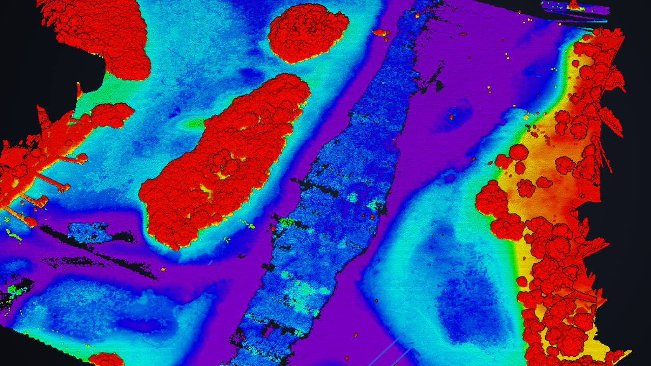
The result is a survey-grade 3D model of terrain you physically cannot see from above, captured without a boat, without sonar, and without anyone getting wet. To understand why that is possible, you only need two ideas: why the laser is green, and what water does to light.
Why a green laser, not infrared
Almost every LiDAR sensor you have seen mapping construction sites and terrain uses invisible near-infrared light at 1064 nanometers. It is superb on solid ground and useless under water: infrared is absorbed almost instantly at the water surface. Point it at the ocean and the pulse dies at the waterline. The bottom never sees it.
Water, it turns out, is picky about color. Its absorption varies enormously across the spectrum, with a pronounced transparency window in the blue-green range. You have watched this happen every time you have looked at an underwater photo: reds and oranges vanish within a few meters of the surface, and everything turns blue-green with depth. That is not the camera. That is water filtering light.
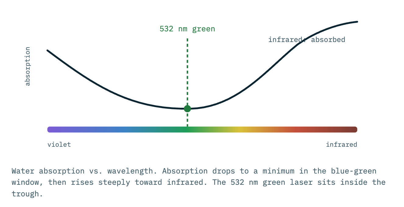
Bathymetric systems exploit that window with a laser at 532 nm, a wavelength that penetrates water with far less attenuation than infrared. And the choice of exactly 532 is an elegant piece of engineering: it is not a separate exotic laser at all. The same 1064 nm infrared source that powers the rest of the industry is passed through a frequency-doubling crystal, which halves its wavelength to precisely 532 nm. One reliable laser, doubled into the color water lets through.
Why not pure blue, which penetrates clear open ocean slightly better? Because real coastal water is not pure. Dissolved organic matter and suspended sediment absorb blue aggressively, shifting the practical transparency window toward green. For the murkier nearshore water most surveys actually deal with, including the saltwater we fly here on the Florida coast, green is the robust choice.
There is a bonus: infrared's failure is useful. Topobathymetric sensors fire both lasers at once. The infrared bounces off the surface and marks the top of the water. The green dives down and finds the bottom. One marks the ceiling, one finds the floor, and the gap between them is the depth.
How it works: one pulse, start to finish
The sensor fires tens of thousands of green pulses per second, sweeping in an oval scan pattern beneath the aircraft. Follow a single pulse and the entire technology reveals itself.
1. The split at the surface
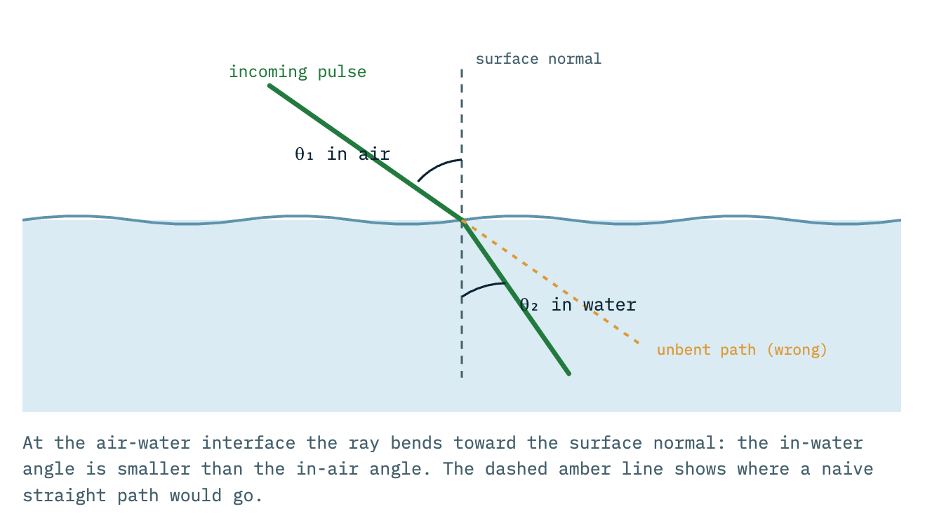
When the pulse reaches the water it splits. Part of the energy reflects straight back, a surface return that pins the exact height of the water. The rest transmits into the water, and the instant it does, it bends.
2. Refraction: the bend you already know
Put a straw in a glass of water and it appears broken at the waterline. The straw is straight; the light is bending as it crosses between air and water. The identical thing happens to the laser. Because water is optically denser, light slows on entry, and that change in speed redirects the ray toward the vertical. The bend is governed by Snell's law, using water's refractive index of roughly 1.33. A pulse arriving at 20 degrees off vertical continues underwater at about 15 degrees. Predictable, consistent, and, as you will see, correctable.
3. Down through the column
As the bent pulse descends it continuously scatters off water molecules, sediment, and plankton, shedding energy the whole way down. This is why water clarity, not laser power, is the practical limit of the technology. A useful rule of thumb from operational systems: maximum depth is on the order of up to three Secchi depths, the depth at which a white disk disappears from view. Clear tropical water can yield well over ten meters of penetration. Stirred-up coastal water may allow only a meter or two. Infrared, for comparison, allows zero.
4. The bounce and the stopwatch
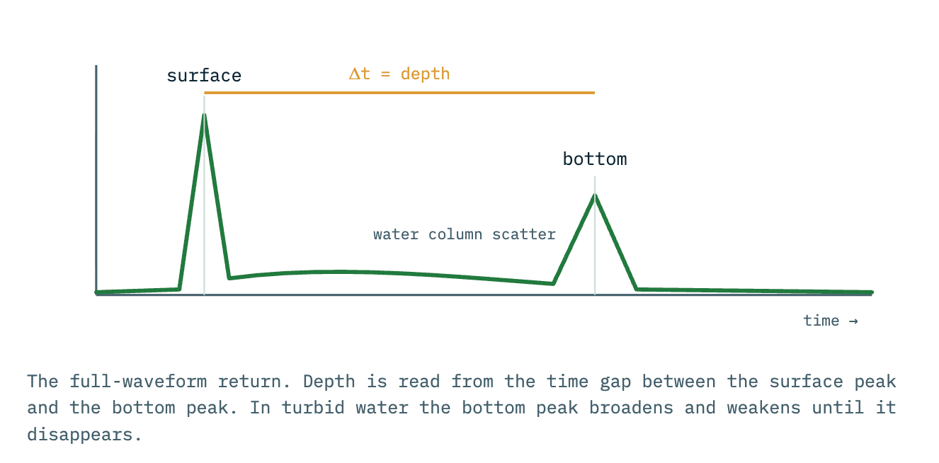
Whatever energy survives the trip reflects off the bottom and climbs back along the same bent path to the sensor. The instrument is fundamentally a stopwatch of absurd precision: it timestamps the pulse leaving and the reflection returning. Light moves at a known speed, so time converts to distance. The full returning signal, recorded as a waveform, contains a sharp surface peak, a sloping tail of water-column scatter, and a second peak for the bottom. The time between the two peaks encodes the depth.
The two corrections that make it accurate
Take the raw measurement at face value and every point is wrong. The light bent, so the bottom is not where a straight line says it is. And the light slowed underwater, so a naive time-to-distance conversion overestimates every depth by roughly a third. Processing software fixes both, for every one of millions of points.
Fix one: the bend
The software ray-traces each pulse. It knows the laser's exact angle from the aircraft's navigation system, finds where that ray meets the modeled water surface, and applies Snell's law to bend it into the true in-water direction. That slides each point sideways to where the pulse actually traveled. Research systems refine this further by modeling the slope of individual waves at the moment each pulse entered, because the bend depends on the tilt of the surface it crossed.
Fix two: the speed
Light in water travels at about 75 percent of its speed in air. The processing splits each pulse's flight time at the surface: the airborne segment uses the air speed of light, and the underwater segment is rescaled to the slower in-water speed. That pulls each point up to its true, shallower depth. Salinity and temperature nudge the refractive index by less than a thousandth, and precision workflows even model the refractive index globally to squeeze out the last of the error.
Two deterministic corrections, applied automatically, and the cloud of raw guesses becomes a survey-accurate model of the seafloor.
Frequently asked questions
Can LiDAR see through water?
Why green and not blue?
How deep can it measure?
How accurate is it?
Does it replace sonar?
Sources and further reading
- Coastal Topobathy Lidar, NOAA Digital Coast National coastal mapping with green-laser bathymetry
- Lidar 101: An Introduction to Lidar Technology, Data, and Applications, NOAA Foundational primer on lidar concepts
- Green, Waveform Lidar in Topo-Bathy Mapping, NOAA NGS Wavelengths, frequency doubling, and waveform principles
- The Use of Green Laser in LiDAR Bathymetry: State of the Art and Recent Advancements (Sensors, 2022) 532 nm generation, Secchi-depth penetration, system design
- The Influence of Refractive Index Changes in Water on Airborne LiDAR Bathymetric Errors (JMSE, 2024) Snell's law, refractive index, salinity and temperature effects
- A Global Refractive Index of Water Data Layer for Bathymetric Lidar (Earth and Space Science, 2025) Refraction correction derivation and error propagation
- Refraction Error Correction of ALB Data Considering Sea Surface Waves (Int. J. Applied Earth Obs., 2021) Wave-slope-aware refraction correction
- Can LiDAR Be Used Underwater?, YellowScan Knowledge Hub Practical overview from a sensor manufacturer
Who made this
I'm Dylan Gorman, founder of Pilotbyte. I've spent about a decade and 5,000+ flight missions in drone mapping, LiDAR, and photogrammetry, and I teach this work to a community of over 200,000 pilots and professionals. This page is the written companion to my full bathymetric LiDAR video, covering the physics, a live coastal capture, the processing workflow, and the final deliverables.
Want to learn drone mapping properly, or need a bathymetric or topographic survey flown?
Explore Pilotbyte